

Pacific Ring of Fire Explained: Why Most of the World's Earthquakes and Tsunamis Happen Here
The Pacific Ring of Fire is responsible for the majority of the world's largest earthquakes, most of its active volcanoes, and some of the most powerful tsunamis ever recorded. Here is why.
If you've ever heard about a major earthquake in Japan, a volcanic eruption in Indonesia, or a tsunami affecting Hawaii or Alaska, you've probably also heard the term "Pacific Ring of Fire." The Pacific Ring of Fire is one of the most active geological regions on Earth — responsible for the majority of the world's largest earthquakes, many of its active volcanoes, and some of the most powerful tsunamis ever recorded.
Understanding the Pacific Ring of Fire helps explain why certain parts of the world experience earthquakes and tsunamis more frequently than others — and why preparedness matters so much for the hundreds of millions of people who live along its arc.
What Is the Pacific Ring of Fire?
The Pacific Ring of Fire is a massive horseshoe-shaped region that surrounds much of the Pacific Ocean. It stretches for approximately 40,000 kilometres (25,000 miles) and follows the boundaries where several major tectonic plates meet.
These tectonic plates are constantly moving, though their movement is typically only a few centimetres each year. Where these plates collide, slide past one another, or move beneath one another, enormous amounts of energy build up over time. When that energy is suddenly released, earthquakes, volcanic eruptions, and tsunamis can occur.
Why Is It Called the Ring of Fire?
The name comes from the extraordinary concentration of volcanoes located around the Pacific Ocean. The region contains approximately 75% of the world's active volcanoes and produces around 90% of the world's earthquakes — including most of the largest earthquakes ever recorded.
Because so many volcanic and seismic events occur around the Pacific basin, scientists refer to the entire region as the "Ring of Fire" — a belt of intense geological activity that encircles the Pacific from New Zealand northward through Asia, across the Aleutian Islands, and down the western coasts of North and South America.
Which Countries Are Part of the Pacific Ring of Fire?
The Ring of Fire spans many countries and territories around the Pacific Ocean. In North America: the United States (Alaska, California, Oregon, Washington, and Hawaii), Canada, and Mexico. In Central and South America: Guatemala, Costa Rica, Ecuador, Peru, and Chile. In Asia: Russia, Japan, the Philippines, and Indonesia. In Oceania: Papua New Guinea, the Solomon Islands, Tonga, and New Zealand.
Many of these regions regularly experience earthquakes, volcanic activity, and periodic tsunami events — making coastal preparedness an important priority for large populations across the Pacific basin.
Why Do So Many Earthquakes Occur Here?
The Pacific Ocean is surrounded by several major tectonic plates, including the Pacific Plate, North American Plate, Eurasian Plate, Philippine Sea Plate, Australian Plate, and Nazca Plate. These plates are in constant, slow motion — and where they meet, the geology becomes highly active.
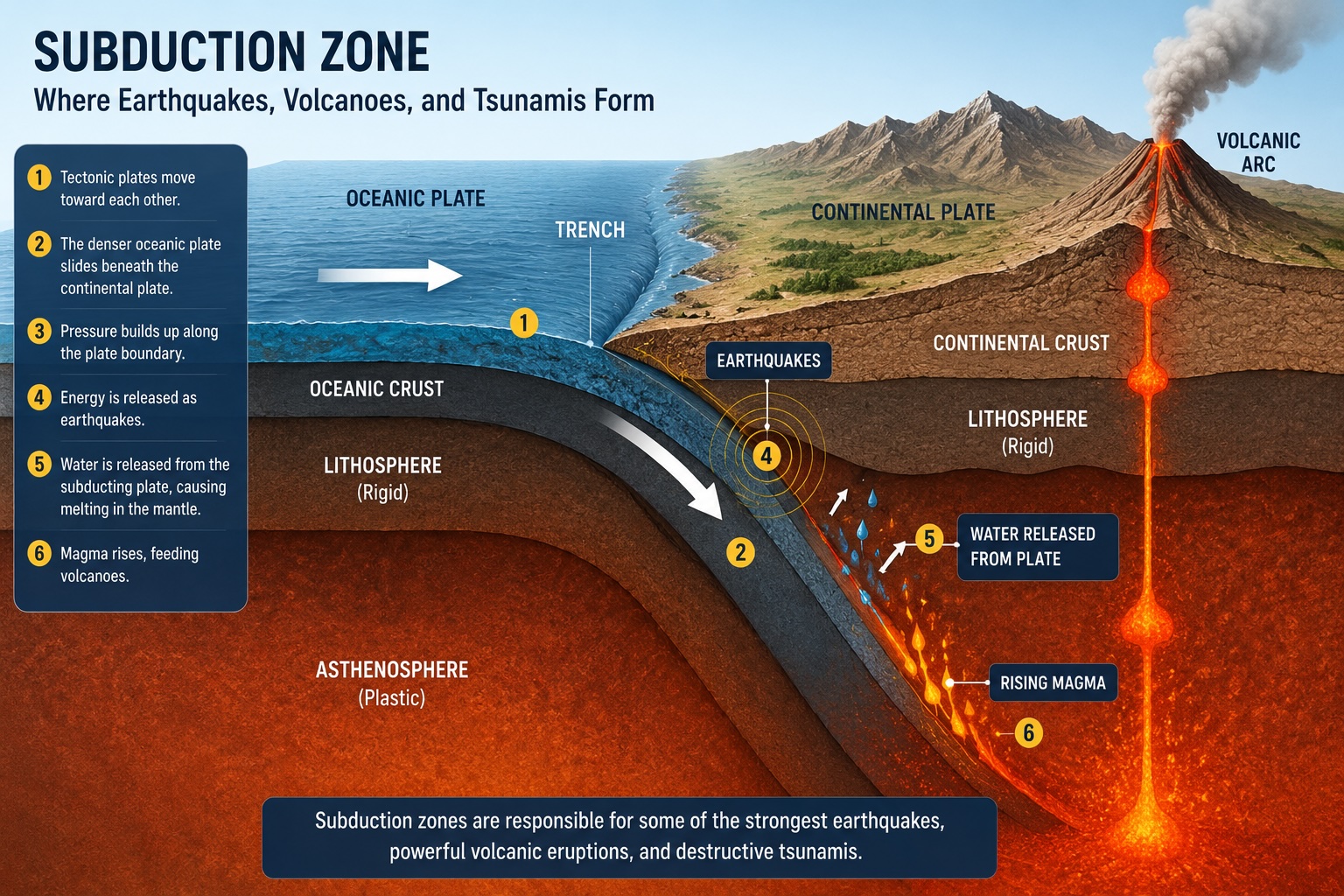
In many locations around the Ring of Fire, one plate slides beneath another in a process known as subduction. Subduction zones are responsible for some of the most powerful earthquakes on Earth, because the plates can become locked together for centuries before suddenly releasing enormous stored energy in a single rupture event.
Why Does the Ring of Fire Produce Tsunamis?
Large undersea earthquakes along subduction zones can suddenly lift or lower vast sections of the ocean floor. When this happens, enormous volumes of water are displaced — and that displaced water becomes a tsunami that radiates outward across the ocean in all directions. This is the mechanism behind most major tsunami events.
Because the Pacific Ring of Fire contains so many major subduction zones beneath the ocean, it produces a large proportion of the world's tsunami-generating earthquakes. Notable examples include the 1964 Alaska earthquake, the 1960 Chile earthquake, the 2004 Indian Ocean earthquake, and the 2011 Japan earthquake — all of which generated devastating tsunamis.
Can Tsunamis Cross the Pacific Ocean?
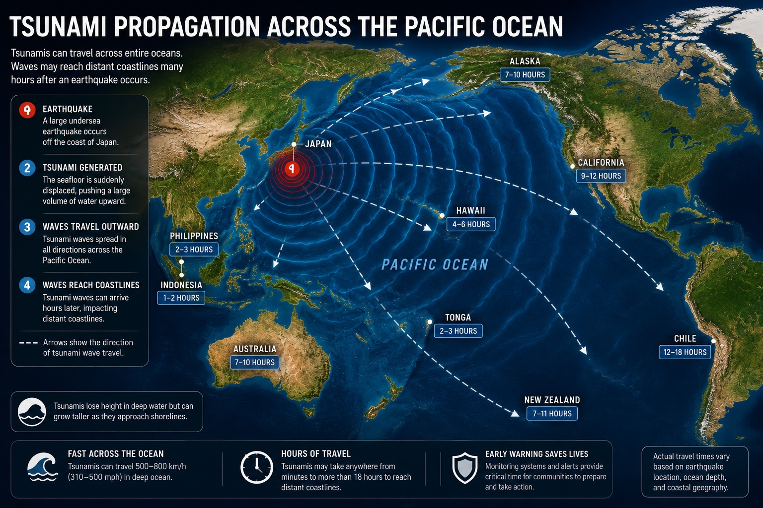
Yes. One of the most remarkable characteristics of tsunamis is their ability to travel enormous distances across the open ocean at speeds approaching 800 km/h (500 mph) — while remaining relatively small in height until they reach shallow coastal waters.
A tsunami generated near Japan may affect Hawaii, Alaska, California, New Zealand, and Chile. Similarly, a tsunami generated near Chile may affect Hawaii, Japan, New Zealand, and the North American coastline. This is why international monitoring networks and cross-border cooperation are essential — a tsunami generated in one country can threaten coastlines on the opposite side of the ocean within hours.
Famous Ring of Fire Events
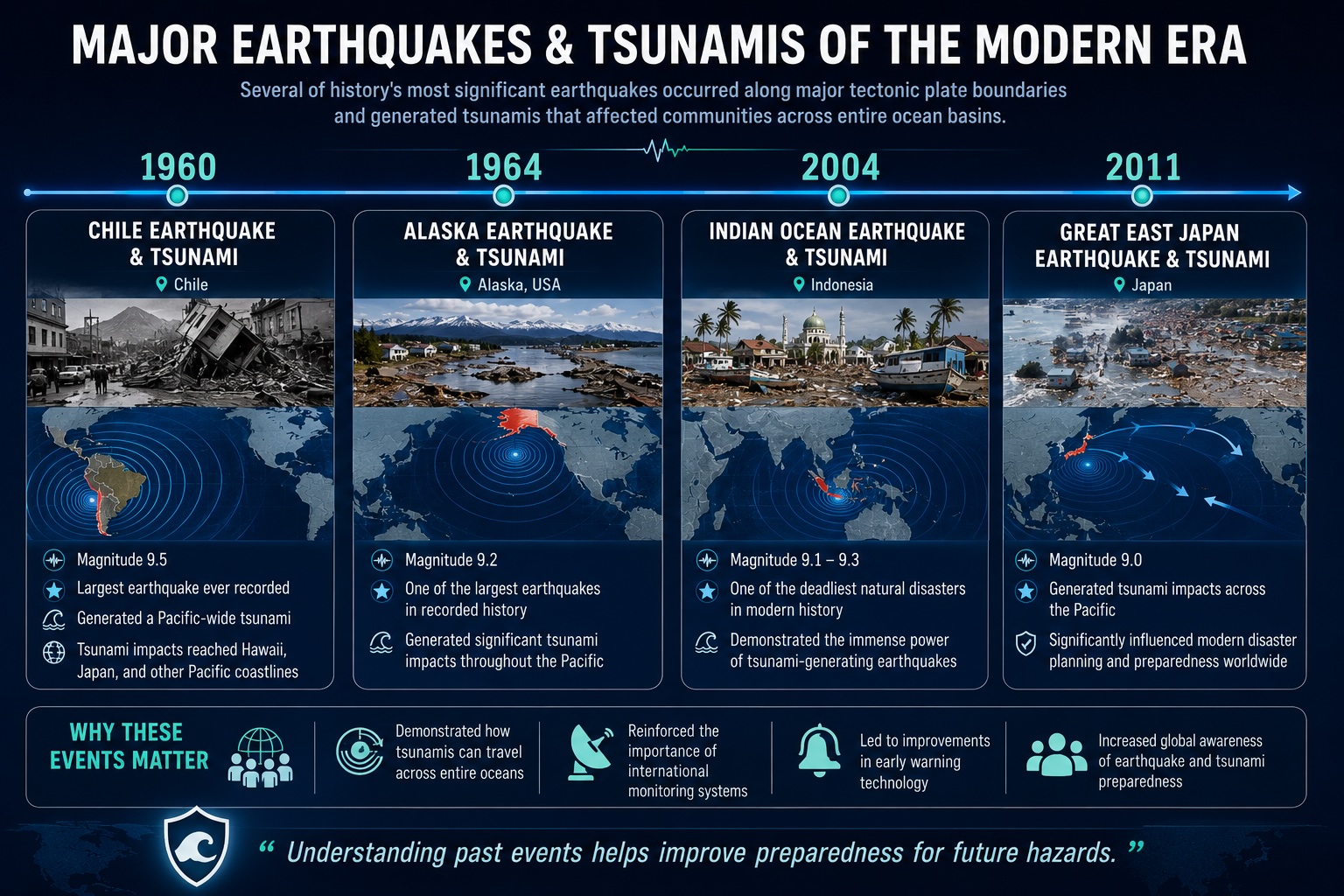
Several of the most significant seismic and tsunami events in recorded history originated along the Ring of Fire. The 1960 Chile earthquake, at magnitude 9.5, remains the largest earthquake ever recorded and generated a tsunami that crossed the entire Pacific Ocean. The 2011 Japan earthquake and tsunami is another landmark event that originated along the Ring of Fire. The 1964 Alaska earthquake, at magnitude 9.2, produced significant tsunami impacts throughout the Pacific as far as California and Hawaii.
The 2004 Indian Ocean earthquake (magnitude 9.1–9.3), though technically at the edge of the Pacific basin, occurred along a major subduction zone and demonstrated the devastating power of tsunami-generating earthquakes. The 2011 Japan earthquake, at magnitude 9.0, generated tsunami impacts across the Pacific and fundamentally changed disaster planning around the world.
Can Scientists Predict Ring of Fire Earthquakes?
No — scientists cannot predict exactly when earthquakes will occur, where the next major earthquake will happen, or how large future earthquakes will be. This remains one of the great unsolved challenges in earth science.
However, scientists can monitor seismic activity continuously, detect earthquakes quickly after they occur, model potential tsunami impacts based on earthquake characteristics, and issue warnings when hazards develop. This monitoring infrastructure — combined with public preparedness and education — forms the foundation of modern tsunami safety.
Early Warning, Not Prediction
[Modern tsunami warning systems](/blog/how-tsunami-warning-systems-work) cannot prevent earthquakes, but they can detect them within seconds and model potential tsunami impacts within minutes — providing critical time for evacuations before waves arrive.
Why Does Understanding the Ring of Fire Matter?
Understanding the Pacific Ring of Fire helps explain why certain regions experience more earthquakes, why some coastlines face higher tsunami risk, and why warning systems and tsunami preparedness matter so much. For the hundreds of millions of people living near Pacific coastlines, awareness of these geological realities is an important part of everyday coastal safety.
Knowing that you live or travel within the Ring of Fire is the starting point for understanding your local hazard environment and taking simple steps to be better prepared.
How Tsunami Shield Supports Awareness
Tsunami Shield helps users stay informed by delivering official tsunami alerts, earthquake monitoring, regional monitoring, and coastal preparedness information directly to their phone. Whether you live along the Ring of Fire or travel to destinations within it, timely information is one of the most effective tools available for reducing risk.
Monitor the Ring of Fire From Your Phone
Tsunami Shield delivers official tsunami alerts and significant earthquake notifications for any location you save — your home, your family's locations, and wherever you travel. Available for iOS and Android.
Final Thoughts
The Pacific Ring of Fire is one of the most geologically active regions on Earth. Its complex system of tectonic plate boundaries produces most of the world's largest earthquakes, many volcanic eruptions, and some of history's most powerful tsunamis.
Although these natural hazards cannot be prevented, understanding why they occur and staying informed through reliable monitoring systems can help individuals and communities improve preparedness and respond more effectively when events occur.
Frequently Asked Questions
What is the Pacific Ring of Fire?
The Pacific Ring of Fire is a horseshoe-shaped belt of tectonic activity that stretches approximately 40,000 kilometres around the Pacific Ocean. It marks the boundaries where several major tectonic plates meet and is responsible for around 90% of the world's earthquakes, 75% of its active volcanoes, and many of the largest tsunamis ever recorded.
Why does the Ring of Fire cause so many earthquakes and tsunamis?
The Ring of Fire sits along major tectonic plate boundaries, particularly subduction zones where one plate slides beneath another. This process builds up enormous geological stress over decades or centuries. When that stress is suddenly released, it generates powerful earthquakes. If the earthquake occurs under the ocean and displaces the seafloor, it can generate a tsunami that travels across the ocean at speeds of up to 800 km/h.
Which countries are most at risk from the Pacific Ring of Fire?
Countries with significant exposure include Japan, Indonesia, the Philippines, New Zealand, Chile, Peru, and the United States (particularly Alaska, Hawaii, and the Pacific Northwest). These nations sit directly on or near major subduction zones and experience regular seismic activity, along with periodic tsunami risk.
Can scientists predict earthquakes along the Ring of Fire?
No — earthquake prediction remains one of the unsolved challenges in earth science. Scientists cannot reliably predict when or where a major earthquake will occur. However, they can monitor seismic activity continuously, detect earthquakes within seconds of occurring, model potential tsunami impacts, and issue warnings rapidly — giving coastal communities valuable time to evacuate before waves arrive.
Read Next
Continue exploring related topics


